
Field manual · 16/17
Settings, Shortcuts & Automation
Twelve sections, in the order they appear. Most of them are covered in the chapter for the feature they configure; this chapter covers the rest, plus the ways to drive the app from outside it.
the settings map
| Section | What is in it | Covered in |
|---|---|---|
| General | Language, map appearance, night vision, quick actions, long press | Below |
| Formats & Units | Coordinate format, datum, north reference, units, time | Below and Coordinates |
| GPS Source | External receiver, NTRIP, altitude source | External GNSS & RTK |
| Team | TAK server, identity, chat, geofence alerts | Team — TAK Server |
| Tracker | Interval, battery profile, auto-pause, calories, track appearance | Tracker |
| Route Navigation | Auto-advance, off-route alerts, rotation, background, tones | Navigation |
| Grid | Grid system, density, per-level colours, line thickness, labels, opacity, custom grids | Maps & Overlays |
| Data Import & Export | Backup & restore, layer export and import | Import, Export & Backup |
| Import Other Formats | Sixteen file formats in | Import, Export & Backup |
| Export Layer | Nine formats out | Import, Export & Backup |
| Map Cache | Cache size, clearing, offline auto-refresh | Maps & Overlays |
| Info | Upgrade, rate, share, manual, tour, contact, privacy | Below |
night vision
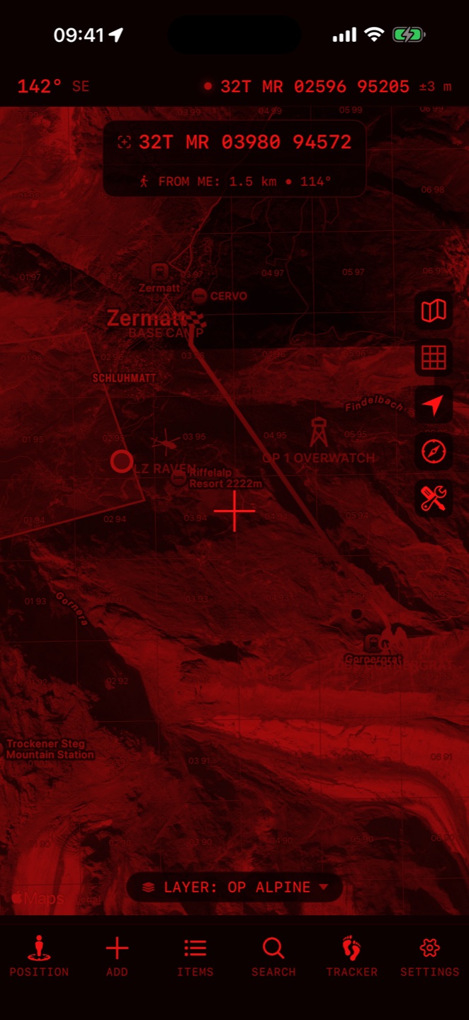
Settings → General → Night Vision: Off, Red or Green. It applies to the entire app, maps included — not just a dark theme, but a genuine single-channel monochrome render that preserves dark adaptation.
general
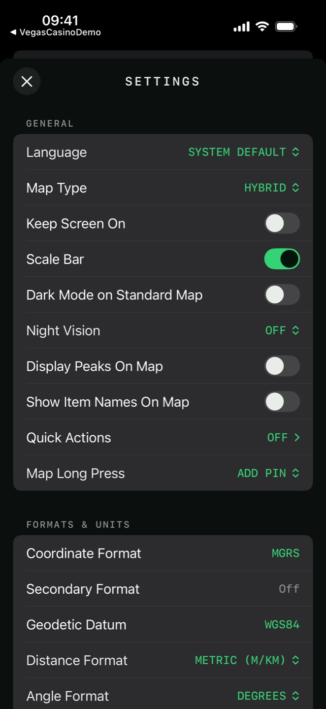
- Language
- System Default, or any of the 23 below
- Map Type
- The same base map picker as the map button
- Keep Screen On
- Stops the display sleeping while the app is open
- Scale Bar
- A distance scale on the map — unavailable on Google base maps
- Dark Mode on Standard Map
- Darkens the road map without switching to night vision
- Night Vision
- Off, Red or Green
- Display Peaks On Map
- Named summits with their altitudes
- Show Item Names On Map
- Draws your item names beside their symbols
- Quick Actions
- Which chips appear above the tab bar
- Map Long Press
- Add Pin, Move Crosshair There or Off
languages
The app ships in 23 languages. It follows your device language by default; the Language setting overrides that, and changing it asks the app to restart.
Arabic, Bulgarian, Chinese (Simplified), Chinese (Traditional), Croatian, Dutch, English, French, German, Indonesian, Italian, Japanese, Korean, Lithuanian, Polish, Portuguese (Brazil), Romanian, Russian, Slovak, Slovenian, Spanish, Turkish and Ukrainian.
quick actions and long press
Settings → General → Quick Actions edits the chip row above the tab bar, using two lists: On the Bar and Available.
siri and app shortcuts
Four App Shortcuts work from Siri, the Shortcuts app, the Action button and Back Tap:
| Shortcut | Say | Opens the app? |
|---|---|---|
| Start Recording Track | "Start recording in Tactical GPS" | No |
| Stop Recording Track | "Stop recording in Tactical GPS" | No |
| Drop Waypoint Here | "Drop a waypoint in Tactical GPS" | Yes |
| Show My Position | "Where am I in Tactical GPS" | Yes |
url schemes
The app answers the Android-style geo: scheme, so a link in a message, an email or
a web page opens straight on the map:
| URL | Result |
|---|---|
geo:46.5,8.0 | Pans there |
geo:46.5,8.0?z=14 | Pans there at zoom 14 |
geo:0,0?q=46.5,8.0(Camp) | Pans there; the label becomes the pin name |
geo:0,0?q=33T 0293000 5010000 | Any coordinate the app's parser understands |
And its own scheme, for use in the Shortcuts app or another tool:
| URL | Result |
|---|---|
tacticalgps://goto?lat=&lon=&z= | Pan to a position |
tacticalgps://pin?lat=&lon=&name= | Drop a named pin |
tacticalgps://record?action=start|stop|toggle | Control the recorder |
tacticalgps://locate | Centre on your position |
q= parameter always wins over the position in front of it, which is
why the geo:0,0?q=… form works.formats and units
Coordinate format, secondary format, datum, precision grids and north reference are covered in Coordinates & Position. The rest of the section:
- Distance Format
- Metric (m/km) · Imperial (ft/mi) · Imperial (yd/mi) · Nautical (nm)
- Altitude Unit
- Meters · Feet
- Speed Unit
- m/s · km/h · mph · knots
- Wind Speed
- The same four, set separately
- Temperature Unit
- Celsius · Fahrenheit
- Angle Format
- Degrees · US/NATO Mils · Soviet Mils · Gradians · Quadrant Bearing
- Time Zone
- Local or Zulu (UTC), with a live Now preview
- Date Format
- Ten patterns, day-first, month-first and year-first
- Use 24-hour Format
- On or off
info
- Upgrade to Pro
- The purchase screen, with the full Free vs Pro comparison
- Rate the App
- Opens the App Store review sheet
- Share the App
- Passes a link to the share sheet
- Manual
- Opens this manual
- App Tour
- Replays the seven-page introduction
- Contact
- Questions, suggestions, bug reports
- Privacy Policy
- The policy in full