
Field manual · 04/17
Coordinates & Position
Reading and writing position is what this app is for. More than thirty coordinate formats, forty-seven geodetic datums, any projected system by EPSG code, and a search field that takes whatever you paste into it.
the position screen
The Position tab is your own location, in full. Cards show the coordinate in your chosen format, accuracy, altitude, speed, heading, the date and time, and the weather where you stand.

Reorder the cards
Hold a card and drag it. Put the two readouts you actually use at the top and the rest below.

Local or Zulu
Tap the TIME card to flip between local time and Zulu. The app-wide default is in Settings → Formats & Units; this is the quick look.
The speedometer
Tap the SPEED card for a full-screen speedometer — an expand glyph in its corner marks it as tappable. Two styles: an analog 270° dial with an auto-ranging scale, or a digital bar. A trip row shows MAX, time-weighted AVG and RESET, counted since you opened the screen.
coordinate formats
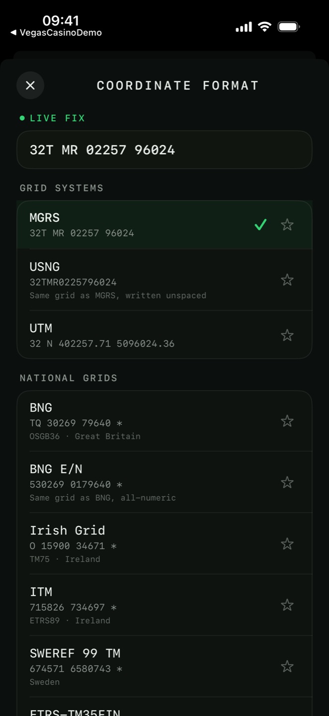
Settings → Formats & Units → Coordinate Format opens the picker, grouped exactly as below. Every row previews your live fix, or a sample position when there is no fix, and can be starred into Favorites at the top of the list.
| Format | Shown as | Note |
|---|---|---|
| Grid systems | ||
| MGRS | 18S UJ 23394 06753 | Military Grid Reference System |
| USNG | 18SUJ2339406753 | Same grid as MGRS, written unspaced |
| UTM | 18N 323394 4306753 | Zone, easting, northing |
| National grids | ||
| BNG | TG 51409 13177 | OSGB36 · Great Britain |
| BNG E/N | 651409 313177 | Same grid as BNG, all-numeric |
| Irish Grid | O 15904 34671 | TM75 · Ireland |
| ITM | ETRS89 · Ireland | |
| SWEREF 99 TM | Sweden | |
| ETRS-TM35FIN | Finland | |
| NZTM2000 | New Zealand | |
| CK-42 (GK) | 7412345 6177345 | Pulkovo 1942 · Russia & CIS · zoned |
| CK-42 (GK) X/Y | 6177345 7412345 | Same grid as CK-42, X (north) first |
| India NSF LCC | 4123456 3456789 | WGS 84 · India · EPSG:7755 |
| Projected | ||
| EPSG PRO | Any projected coordinate system by EPSG code | |
| Global codes | ||
| Plus Code | 8FVC9G8F+6XQ | Open Location Code · worldwide, ~3 m |
| Maidenhead | JN47gj12ab | Amateur radio QTH locator · worldwide |
| India Sheet (OSM) | F44H13 | Survey of India Open Series 1:50 000 sheet |
| India Sheet (IAC) | 53H/13 | Survey of India older-series 1:50 000 sheet |
| Degrees | ||
| DDM | DDD° MM.mmm' | Degrees and decimal minutes — marine & aviation |
| DMS | DDD° MM' SS" | Also with one and two decimal seconds |
| DD | DDD.dddddd° | Four, five or six decimal places |
18SUJ2339406753, not 18S UJ 23394 06753.F44H13) and
the older IAC notation (53H/13) respectively, so you can name the map sheet you are
standing on.secondary readout, favourites and utm options
Secondary Format
Settings → Formats & Units → Secondary Format puts a second line under the primary one on the Position screen, the crosshair panel and the pin preview. Set it to Off or to any format. MGRS on top and decimal degrees underneath covers both the radio and the spreadsheet.

Favorites
Star the formats you switch between and they pin to the top of the picker, so changing format is two taps rather than a scroll through the whole list.
UTM options
When UTM is your primary or secondary format, two more rows appear: UTM Decimals (0, 1 or 2) and UTM Unit (Meters or Feet).
any epsg system PRO
Choose Projected (EPSG) in the format picker to open Coordinate Systems: 57 curated national grids grouped by country, a search field, and a free-text Any EPSG code box with a Use button.
The curated list covers Australia, Austria, Belgium, Brazil, Bulgaria, Canada, Croatia,
Czechia, Estonia, France, Germany, Great Britain, Greece, Hong Kong, Hungary, India, Israel,
Italy, Japan, Latvia, Lithuania, Luxembourg, Mexico, Morocco, the Netherlands, Norway, Poland,
Portugal, Romania, Slovakia, Slovenia, South Africa, South Korea, Spain, Sweden, Switzerland,
Taiwan and the United States — for example RGF93 / Lambert-93 (2154), CH1903+ / LV95
(2056), Amersfoort / RD New (28992), Belgian Lambert 2008
(3812), the Austrian GK zones (31254–31256) and
OSGB36 / British National Grid (27700).
geodetic datums
Settings → Formats & Units → Geodetic Datum lists 47 datums, searchable by name, region or EPSG code. The default is WGS84, which is what GPS itself reports.
The list covers ETRS89, ED50 with its regional variants, NAD27 and NAD83, OSGB36, TM75 and IRENET95, RGF93, DHDN, Amersfoort, CH1903+, SWEREF99, Pulkovo 1942, Tokyo and JGD2011, Korean 2000, CGCS2000, Hong Kong 1980, Indian 1975, Kertau, Timbalai, Israel 1993, Qatar, Nahrwan, Adindan, Arc 1950 and 1960, Minna, Hartebeesthoek94, SAD69, SIRGAS 2000, AGD66, GDA94, GDA2020, NZGD49 and NZGD2000, among others.
precision datum grids PRO
A datum conversion done with a seven-parameter transformation is good to about a metre. A grid shift file does it properly, by interpolating the actual distortion of the national survey. The datum picker's Precision Grids section downloads them.
| Grid | Applies to | Download | Accuracy |
|---|---|---|---|
| OSTN15 | OSGB36 · Great Britain | ~5 MB | ±0.10 m |
| OSi / OSNI | TM75 · Ireland | ~1 MB | ±0.15 m |
| NADCON | NAD27 · US (CONUS) | ~6 MB | ±0.15 m |
| NTv2 | NAD27 · Canada | ~13 MB | ±0.15 m |
north reference and angle format
There are three norths and they disagree. Settings → Formats & Units → North Reference picks which one every bearing in the app uses:
- True North
- The geographic pole. Tagged T.
- Magnetic North
- What a compass needle points at. Tagged M.
- Grid North
- The vertical grid lines on your map sheet. Tagged G.
3.4° E. Declination comes from the device compass; convergence is computed from
your grid zone.
Angle Format
Degrees (360), US/NATO Mils (6400), Soviet Mils (6000), Gradians (400) or Quadrant Bearing — the surveyor's N 45° E notation, which never exceeds 90°.

Bubble level
The compass carries a bubble level under the bearing. It turns green inside ±3° — the tolerance a hand-held bearing actually needs. It is hidden on devices without motion sensing.
search and the any-format field
The Search tab has four tabs — Coordinate, Grid, Search Pins and Address Search — and above them a single Any Format field.

Paste anything
Paste or type a position in almost any notation and the app identifies it, tells you which format it recognised, and fans the value out into the other tabs so GO just works. Unrecognisable text reports Not recognized rather than guessing.
The field accepts MGRS and USNG; UTM with a band letter or a hemisphere letter, including
zero-padded seven-digit eastings such as 33T 0293000 5010000; Plus Codes, full or
short; Maidenhead locators from two to ten characters; decimal degrees, degrees-decimal-minutes
and degrees-minutes-seconds in every common spelling; lettered or numeric national grid
references; and EPSG:<code> x y triples.

Project a point
Project From Me and Project From Center compute a new position from a bearing and a distance — the digital version of a resection, and how you plot a point given as "1 200 m on a bearing of 073".
9G8F+6XQ works without the region prefix when you are already nearby.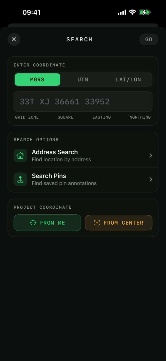
the coordinate converter
Tools → Coordinate Converter converts between MGRS, UTM and Lat/Lon on a dedicated screen, with the same input mask, parser and validation the Search screen's GRID tab uses. Free.