Field manual · 05/17
Pins & Shapes
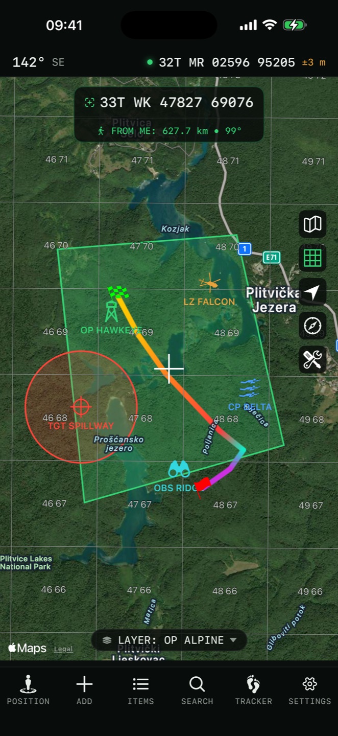
Everything you draw on the map is an item, and every item lives in a layer. Pins, labels, photos, elevation readings, routes, areas, circles, rectangles and freehand sketches all share the same editor, the same styling and the same export path.
creating items
The Add tab draws at the crosshair: position the map, pick a type, place your points. The Items tab creates the same things from a form, which is faster when you are copying coordinates off a sheet of orders.
Pin
A named point with a description, colour, icon and altitude. It can carry photos, PDFs, files and voice memos.
Polyline / Route
A multi-point line with live length as you build it, an elevation profile, and per-segment readouts if you style it as measured.
Polygon
A closed area with live area and perimeter.
Circle
A centre and a radius. Also the shape you geofence most often.

Rectangle
A box by width and height — a grid square, a search box, a drop zone.
Label
Text drawn directly on the map instead of a symbol, with its own text colour, background and size. For naming a feature, an area or a phase line.
Photo
A picture drawn on the map as a bordered thumbnail at the position it belongs to.
Elevation / Depth PRO
A saved terrain reading. An elevation point records ground height; a depth point records water depth. Each carries the date it was read and a note that the value is modelled reference data — not a survey, and not a nautical chart.
Freehand
Choose how you draw first: Draw with Finger sketches strokes straight onto the map, while Draw with Cursor keeps the map pannable and draws the line at the centre crosshair as you move — the steady option on a vehicle mount. A cursor stroke ends after a short pause; undo removes a whole stroke at a time.
Directions PRO
A generated route between points, following roads or trails. See Navigation & Directions.
the item editor
Every item opens the same form. A pin shows:
- Title
- The name drawn on the map when item names are shown
- Description
- Free text, carried into exports
- Coordinate
- Tap to set — type it, or take it from the crosshair
- Altitude
- In your altitude unit, with an Auto-fetched value from terrain data
- Color
- The symbol colour
- Background
- The plate behind the symbol
- Text Color / Text Size
- For labels
- Icon
- The built-in library, an APP-6 symbol or one of your own
- Icon Size
- 50 % to 150 %, in 10 % steps — shown when an icon or APP-6 symbol is selected, so one pin can be made to stand out
- Folder / Tags
- Filing and cross-cutting labels — see Items, Folders & Tags
- Attributes
- A free-form table of extra fields — see below
- Preview
- How the item will actually look on the map
- Add Attachment
- Camera, Photo Library, Files or Voice Memo
icons and nato symbols
The built-in library
130 glyphs grouped into activities, animals, places, vehicles and general markers. 28 of them are free — plain dots and outlines, the activity set, the animal set and a handful of places — and the rest are part of Pro.

APP-6 / NATO symbols
The full military symbology set, searchable, with affiliation chips for Friend, Hostile, Neutral and Unknown. Changing affiliation reshapes and recolours the frame the way the standard requires, and the label colour follows.
Custom icons PRO
The editor's Custom Icons section loads your own PNG, JPEG or HEIC images from File or Photo. They are stored with the app, travel inside exported layer bundles and are written into KMZ, so a custom symbol set survives being handed to someone else.
attachments
Add Attachment in a pin's editor takes five kinds of file:
| Kind | Notes |
|---|---|
| Photo | From the camera or the library. Downscaled to 2048 px and re-encoded as JPEG; files already within that stay untouched, so a screenshot is not smeared. |
| Video | Record Video on the spot — up to one minute — or pick a clip from the library or Files, up to three minutes. Clips are transcoded down until they fit, so a long 4K recording does not bloat the item. |
| Orders, a scanned map extract, a datasheet. | |
| Voice Memo | Recorded on the spot with a level meter, then kept or discarded. AAC, mono, up to ten minutes. |
| File | Anything else from Files, including an audio file you recorded elsewhere. |
The in-app camera geotags
A photo taken from the pin editor is stamped with the position, altitude and both true and magnetic heading — so the picture records where it was taken and which way the camera was pointing.
attributes
Every item — pin, line, area or shape — carries an Attributes table: a free-form list of name-and-value fields for anything the standard form does not have a box for. A frequency, a grid-square code, a casualty count, a sensor reading, a source reference.
Editing
The editor's Attributes section adds a row at a time — an Attribute Name and a Value — with Add Attribute for the next and a minus button to drop one. The item's details screen shows the table read-only when it has any.
<ExtendedData> and read back from it, and they map to a GeoJSON feature's
properties. A layer you import from another GIS keeps its attribute columns, and a
layer you export carries yours out. See Import, Export &
Backup.line and shape styling
A polyline can be drawn in six styles:
| Style | Use |
|---|---|
| Solid | The default line |
| Arrow | Direction of travel or of attack |
| Dotted | A planned or notional route |
| Dashed | A boundary or phase line |
| Dashdot | A second class of boundary |
| Measured | A solid line carrying a distance and azimuth capsule and a direction chevron on every segment |
Circles, rectangles and polygons additionally offer:
- Fill Color
- The interior, independent of the stroke
- Width
- Stroke weight
- Radius / Width / Height
- Exact dimensions in your units
- Notify on
- Turns the shape into a geofence
- Elevation Difficulty
- Gentle, Easy, Moderate or Steep
geofences and pin alerts
Set Notify on in a circle, rectangle or polygon editor and the shape starts watching for you. Triggers are Enter, Exit or Both, and the alert arrives as a notification even with the app in the background.

Per-pin proximity alert
A pin can watch for you too, without drawing a shape. Switch on Proximity Alert in the pin editor, set an Alert Radius (default 100 m, down to 10 m) and a Notify on trigger — Enter, Exit or Both. It behaves like a circular geofence centred on the pin, and the approach tones below apply to it as well.
Approach tones
Settings → Route Navigation → Geofence Approach Tones adds audio. The radius is split into three rings at full, half and quarter distance. Crossing inwards plays one, two or three rising beeps; crossing outwards plays a wrong-way beep, doubled when you leave the outer ring. Inside the innermost ring it goes silent. Tones are at least four seconds apart.
editing on the map
Vertex editing
Tap a saved line or area and choose Edit on Map to work on its points in place. Each vertex gets a square handle; tap one and a capsule appears with Move Here (snaps the vertex to the crosshair), + Point (inserts after it), − Point (removes it, down to the two-point or three-point minimum) and Done. Edit via Form opens the same item as a list instead.
Connect to Pin
Tap a saved pin and choose Connect to Pin…, then pick another, and a measured line is drawn through them — named for its endpoints and carrying the distance along it. A quick leg between two known points without drawing by hand.
Project Waypoint
Project Waypoint… on a pin computes a new point a bearing and distance away from it, with a Back Bearing option — the way to plot "1 200 m on 073 from the OP" straight off an existing pin.