Field manual · 02/17
Maps & Overlays
The Map Type button is the map sheet: which base map you are on, what is stacked over it, which of your own maps are loaded, what is downloaded for offline use, and the presets that restore a whole setup in one tap.
base maps
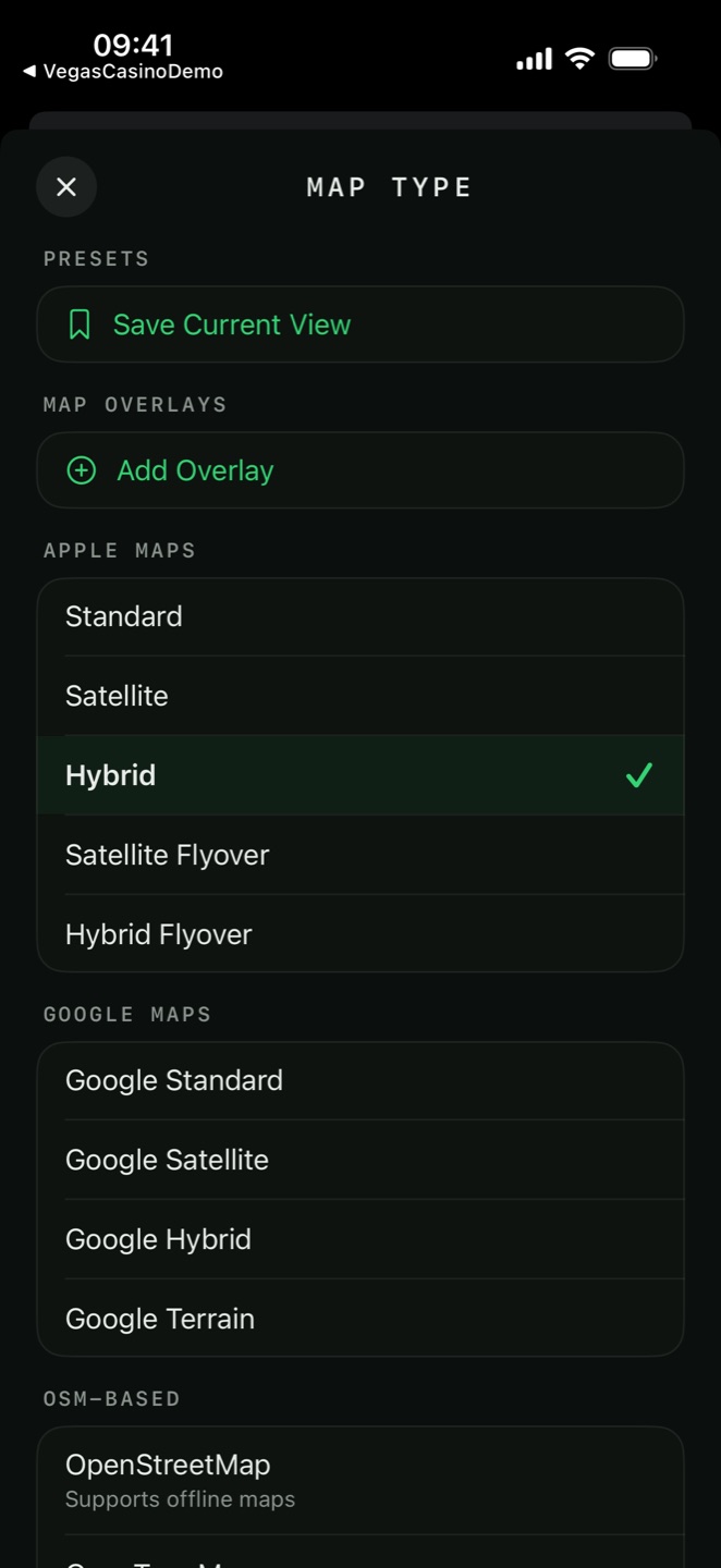
Twenty base maps, grouped in the Map Type sheet as Apple Maps, Google Maps, Mapbox, OSM-based, USGS and Custom Maps — plus the offline-only Satellite (Esri) you pick when downloading a region. They render on four engines — MapKit, MapLibre, Google and Mapbox — and your grid, pins and tools look the same on all of them.
| Base map | Notes | 3D | Contours |
|---|---|---|---|
| Apple Maps | |||
| Standard | Road map | ✓ | — |
| Satellite | Imagery | ✓ | — |
| Hybrid | Imagery with labels | ✓ | — |
| Satellite Flyover | Permanently 3D | always | — |
| Hybrid Flyover | Permanently 3D, labelled | always | — |
| Google Maps | |||
| Google Standard / Satellite / Hybrid / Terrain | No scale bar, no PDF printing | — | — |
| Mapbox — Pro, online only | |||
| Mapbox Standard | Vector map with 3D terrain and buildings | ✓ | — |
| Mapbox Satellite | Imagery draped over 3D terrain | ✓ | — |
| Mapbox Outdoors | Topographic, over 3D terrain | ✓ | ✓ |
| Mapbox Streets | Street map over 3D terrain | ✓ | — |
| OSM-based | |||
| OpenStreetMap | The standard OSM raster map | — | — |
| OpenTopoMap | Topographic, contours printed into the tiles | — | ✓ |
| Carto Topo Map | Vector topo map with live hillshade | — | ✓ |
| USGS (United States) | |||
| USGS Topo | The National Map topographic series | — | — |
| USGS Imagery | Aerial imagery with topographic detail | — | — |
| USGS Hydro | Hydrography | — | — |
| Custom | |||
| Custom Map | Your own XYZ source, MBTiles or imported raster | — | — |

Mapbox — the 3D engine PRO
The Mapbox group adds a fourth rendering engine built for relief. All four styles drape over real elevation so a tilt shows the actual shape of the ground, and Mapbox Standard adds extruded 3D buildings. It is a Pro, online-only engine — the styles stream from Mapbox and are not part of an offline pack.
map overlays
Map Type → Map Overlays → Add Overlay builds an ordered stack of raster layers drawn over the base map. This is map imagery — trails, pistes, sea marks, your own tiles — and is not the same thing as the layers that hold your saved items.
Built-in overlays PRO
Ready-made layers from OpenStreetMap, drawn over any base map: Hiking Trails (waymarked hiking routes and footpaths), Ski Trails (ski pistes and marked ski routes), Cycling Trails (signposted cycling route networks) and Sea Marks (buoys, beacons and navigation marks).

Your custom maps
Any raster source you added yourself in Map Type can be stacked as an overlay too — an imported GeoTIFF over satellite imagery, for example.
Each entry in the stack has its own controls:
- Opacity
- 20 % to 100 %
- Brightness
- −100 % to +100 %
- Contrast
- −100 % to +100 %
- Saturation
- −100 % to +100 %, where −100 % is greyscale
- Hue
- 0° to 360°, in 5° steps
- Invert Colors
- Flips the tile — turns a white-background topo sheet dark
- Erase Color
- Makes one colour transparent so the map underneath shows through — White, Black or a colour you pick, with a Tolerance slider. The quick way to drop the paper background out of a scanned sheet or a GeoPackage's white fill.
- Move Up / Down
- Reorders the stack
- Show / Hide
- The eye, without removing the entry
- Reset
- Returns opacity and every adjustment to default
- Remove
- Takes the layer out of the stack
your own maps PRO
Map Type → Custom Maps → Add Custom Map loads a map the app does not ship.
- Name
- Required — how it appears in the map list
- Source Type
- An online tile service, or a file on the device
- URL Template
- An XYZ or TMS template
- MBTiles File
- Import MBTiles File from Files, or Download MBTiles from URL
- Max Zoom
- How deep the source goes
- Tile Size
- 256 or 512 pixel tiles

Import a scanned or georeferenced map
Map Type also imports GeoTIFF, GeoPDF and AlpineQuest .aqm files. The app reads the file's coordinate system, ground resolution and zoom range, converts it into a tile pyramid, then reports that it was added to Custom Maps and is now the active map — or tap Add as Overlay Instead to stack it over the base map you are on rather than replacing it.
.tif, GeoPDF, .aqm,
.gpkg or .mbtiles into Tactical GPS from Files, Mail or any share sheet and
it goes straight into Custom Maps. A raster MBTiles asks first: Use as Base Map or
Add as Overlay Layer; a vector MBTiles is used as the base map directly.image overlays PRO
An image overlay pins a flat picture to the map — a hand-drawn sketch map, a scan without a coordinate system, an operation graphic — and stretches it to fit the ground.
- Open Map Type → Image Overlays → Add Image from Photos and pick a picture.
- You drop into placement: drag and pinch the image until it sits over the right ground.
- The overlay joins the list with its own Opacity slider (10 % to 100 %), a Reposition button to place it again, and Delete.
the loaded maps panel
Once anything is stacked on the map — overlays, image overlays, several item layers — a Loaded Maps button appears in the control column with a count badge. It opens a panel that puts the whole stack in one place without going back into the Map Type sheet.
- Basemap
- Shows the current base map; tap to open Map Type
- Map Overlays
- Touch-and-hold to drag an overlay up or down the stack, each with an opacity slider (20 % to 100 %) and an eye PRO
- Image Overlays
- Opacity and show/hide for each placed picture
- Item Layers
- Your saved-item layers, each with an opacity slider, an eye and an Active badge on the editable one
offline maps PRO
Two things work offline, and they are different. Caching is automatic: every tile you look at is kept, so ground you have already scrolled over stays available with no signal. An offline region is deliberate: you box an area and download it whole, in advance.
- Position and zoom the map over the area you want. The box follows the screen.
- Open Map Type → Offline Maps → Add Offline Region.
- Give it a Region Name — this is required.
- Pick the base map to bake into the pack. This is also where Satellite (Esri) lives — a high-resolution imagery layer offered only here, for offline use.
- Decide whether to Include Map Layers (the overlay stack) and Include Terrain Data (elevation for contours and analysis).
- Check the estimate — the panel shows roughly how many tiles and how many megabytes.
- Download.
| The panel says | Meaning |
|---|---|
| Zoom level OK | The area will download at a sensible size. |
| Large area – zoom in more | It will work, but expect a big download. |
| Area too large – zoom in | Refused. Box a smaller area. |
| Too many tiles – zoom in | Refused on tile count rather than area. |
Each downloaded region's row menu offers:
map presets PRO
A preset is a named snapshot of your whole map setup. Map Type → Presets → Save Current View stores it; tapping the row applies it.
A preset captures the base map, which custom source is active, the entire overlay stack with every per-layer adjustment, the basemap adjustments, whether the grid is on and its system, density and opacity, the dark-mode setting and the 3D setting.
touch lock
The padlock in the control column freezes every map gesture — pan, zoom, rotate and tilt — on all four engines. The button turns red while locked, and the lock survives switching base maps.
the grid overlay
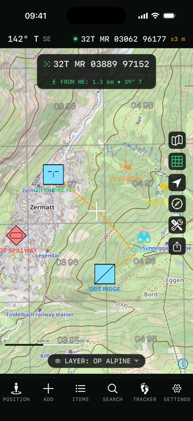
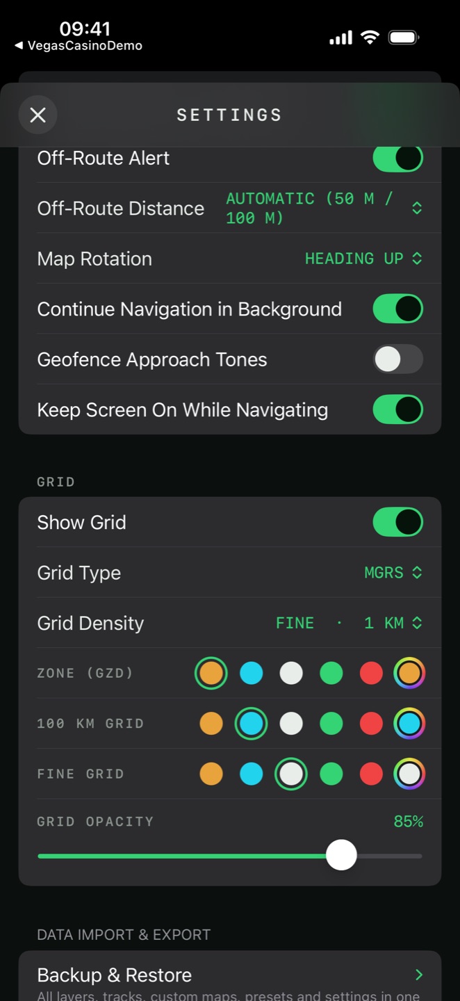
The grid button on the map shows and hides it; Settings → Grid controls how it looks. All four map engines draw it from the same source, so it registers identically on Apple, Google, MapLibre and Mapbox maps.
- Grid Type
- MGRS, UTM, Lat/Lon, CK-42, CK-42 X/Y or Custom
- Grid Density
- Coarse · 100 km, Standard · 10 km, Fine · 1 km, Ultra · 100 m
- Colours
- Three levels, named for the system in use
- Line Thickness
- ×0.5 to ×3, in 0.25 steps
- Grid Opacity
- 20 % to 100 %, in 5 % steps
- Label switches
- Turn the zone / square and the line-value labels on or off

CK-42 grids
CK-42 and CK-42 X/Y draw the Soviet Gauss-Krüger grid on Pulkovo 1942 — the one printed on Warsaw-Pact map series. The two differ only in axis order, matching the sheet or the receiver in front of you. These are grid overlays; the matching coordinate readout is a separate setting — see Coordinates.
Custom reference grid
Set Grid Type to Custom and Manage Custom Grids builds your own lettered-and-numbered grid: an origin and corner, cell width and height, a rotation, the number of columns and rows, and whether each axis is lettered or numbered (with an optional Skip I and O). Labels sit along the edges or in every cell. Up to 400 cells — a drop-zone grid, a sector overlay, a search-box reference of your own.
map cache
Settings → Map Cache → Clear Cache shows how much space the automatic tile cache is using and empties it.